


Autonomous Vehicle Fleet
| ICAV1 | |
|---|---|
|
Intelligent and Connected Autonomous Vehicle. Fundings: PUV in the framework of SophiaTech2.0 project. Description: ICAV1 is an Intelligent and Connected Autonomous Vehicle.composed of a Renault ZOE robotized by Ecole Centrale of Nantes (by the team setup by Philippe Martinet in LS2N/ARMEN). The robotization allows to have access to the control of the steering angle, the braking torque, the acceleration, the gear box, and the blinking light. The global architecture is done under ROS2. It inlcudes vision/Lidar/IMU/RTK-GPS sensors. Applications: Data collection, Mapping, Localization, SLAM, Autonomous navigation |
  |
| ICAV2 | |
|
Intelligent and Connected Autonomous Vehicle. Fundings: PUV in the framework of SophiaTech2.0 project. Description: ICAV2 is an Intelligent and Connected Autonomous Vehicle.composed of a Renault ZOE robotized by Ecole Centrale of Nantes (by the team setup by Philippe Martinet in LS2N/ARMEN). The robotization allows to have access to the control of the steering angle, the braking torque, the acceleration, the gear box, and the blinking light. The global architecture is done under ROS2. Applications: Data collection, Mapping, Localization, SLAM, Autonomous navigation |
 |
Outdoor ground robots
| SUMMIT-HM | |
|---|---|
|
Robotnik SUMMIT-HM off-road robot. Fundings: AGRIFOOD-TEF project Description: SUMMIT-HM is a customized and updated version of the Summit-XL offroad mobile robot from robotnik. It is an instrumented robots with many sensors (RTK GPS, Lidar, Camera, IMU Communications Applications: Data collection, Mapping, Localization, SLAM, Autonomous navigation |
  |
| HUNTER2 | |
|
AGILX HUNTER 2 outdoor robot Fundings: NINSAR project. Description: HUNTER 2.0 is based on Ackermann steering. Therefore, it has similar characteristics to cars. It is equipped with a rocker arm suspension which can pass common obstacles such as speed bumps, etc. HUNTER 2.0 is frequently used for autonomous driving education and research, indoor and outdoor security patrolling, environment sensing, general logistics and transportation.. The global architecture is done under ROS2. Applications: Data collection, Control, Autonomous navigation |
 |
Indoor mobile robots
| Scout Mini | |
|---|---|
|
AGILX Scout mini Fundings: EPISUD & SAMURAI project. Description: SCOUT-Mini has been integrated to demonstrate autonomous navigation capabilities in encumbered and crowded environment. This platform is composed of: Applications: Data collection, Mapping, Localization, SLAM, Autonomous navigation, Social navigation |
 |
| E-Wheeled | |
|
AMDT E-Wheeled Fundings: INRIA project. Description: E-WHEELED is an AMDT Inria project (2019-22) coordinated by PhilippeMartinet. The aim is to provide mobility to things by implementing connectivity techniques. It makes available an Inria expert engineer (Nicolas Chleq) in ACENTAURI in order to demonstrate the Proof of Concept using a small size demonstrator. Due to the COVID19, the project has been delayed. Applications: Moving of things |
 |
UAV Fleet
| UAV1 | |
|---|---|
|
DJI Matrice 300 Fundings: EPISUD & SAMURAI project. Description: The DJI Matrice 300 RTK is a platform inspired by modern aviation systems. Offering up to 55 minutes of flight time, advanced AI capabilities, 6-way sensing and positioning and more, the Matrice 300 RTK sets a whole new standard, combining high-performance intelligence and unrivalled reliability. It is equipped with a stereo camera system. The global architecture is done under ROS2 using a jetson ORIN nano. Applications: Data collection, Mapping, Localization, SLAM, Autonomous navigation, Monitoring of environment |
 |
| UAV2 | |
|
DJI Matrice 300 Fundings: EPISUD & SAMURAI project. Description: The DJI Matrice 300 RTK is a platform inspired by modern aviation systems. Offering up to 55 minutes of flight time, advanced AI capabilities, 6-way sensing and positioning and more, the Matrice 300 RTK sets a whole new standard, combining high-performance intelligence and unrivalled reliability. It is equipped with a multi-spectral camera. The global architecture is done under ROS2 using a jetson ORIN nano. Applications: Data collection, Mapping, Localization, SLAM, Autonomous navigation, Monitoring of environment |
 |
| UAV3 | |
|
DJI MAVIC3 Fundings: MOBIDEEP project. Description: The DJI Mavic 3 offers a dual camera sensor including a Hasselblad micro 4/3 and a 28x hybrid zoom camera, coupled with the latest technologies for unprecedented flight performance. The 46-minute battery life and Ocusync 3+ transmission offer exceptional freedom. Applications: Data collection, Monitoring of environment |
 |
Facilities
| Mobile Living LAB | |
|---|---|
|
Mobile living Laboratory (MLL) Fundings: Agrifood-Tef project Description: The MLL is a moving platform designed to perform physical field testing (Navigation algorithms, Monitoring of health and growth, Sensors and robots testing) and dataset acquisition in real agricultural sites. Applications: datasets acquisition, localization, Mapping, Simultaneous Localization AndMapping (SLAM), autonomous navigation (path planning and tracking, Geofencing). |
  |
| Azur Arena Parking | |
|---|---|
|
Parking Azur Arena Fundings: Own by CASA Description: INRIA has access to a private parking of size 100 m x 100 m at AzurArena, where we carry out different experiments related to Autonomous Vehicles (AV), Autonomous Ground Robots (AGRs), and Unmanned Aerial Vehicles (UAVs). The current site can be equipped with a 4G/5G network, so that all robots can communicate on same network.. Applications: Data collection, Sensors Calibration, Testing, Validation, and Benchmarking of Localization, Mapping, SLAM, and Navigation Algorithms Location: Maps |
 |
| Inria Private Parking | |
|---|---|
|
Private Parking at Inria Site Fundings: own by Inria Description: At INRIA, we have a private parking of size 85 m x 13m surrounded by plants and trees, which make it a dynamic environment to carry out some outdoor development, testing, and validations experiments for Autonomous Ground Robots (AGR), and Unmanned Aerial Vehicles (UAVs). It provides a good environment to test the robots mobility algorithms in forest like natural environment. Applications: Data acqusition, Sensors integration testing, Pretesting AI and Robotic Algorithms for AGRs and UAVs Location: Maps |
 |
| Maison du coeur | |
|---|---|
|
Maison européenne du coeur Fundings: own by Maison du coeur Description: In Sophia Antipolis, we have access to the Maison européenne du coeur surrounded by plants and trees for carrying out some outdoor development, testing, and validations experiments for Autonomous Ground Robots (AGR), and Unmanned Aerial Vehicles (UAVs). It provides a good environment to test the robots mobility algorithms in forest like natural environment. Applications: Data acqusition, Sensors integration testing, Pretesting AI and Robotic Algorithms for AGRs and UAVs Location: Maps |
 |
| DRONIX | |
|---|---|
|
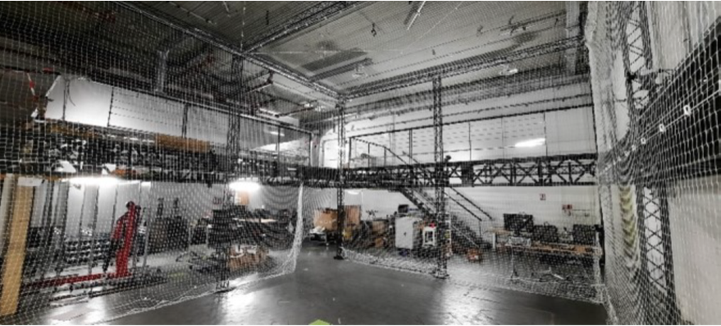
UAV Arena Dronix Fundings: Agrifood-Tef project Description: DRONIX is an indoor UAV (Unmanned Aerial Vehicle) Arena of size 5 m x 6 m x 7 m. It is a specialized facility designed for the development, testing and demonstration of mobility algorithms for UAVs and AGRs in a controlled indoor environment. It can be considered as a fully controlled and customisable facility (light, volume, ground truths, customer object placement etc.) for preliminary testing of Sensors, UAV and AGR functionalities. Applications: Data collection, Sensors Calibration, ground truth localization with 12 Cameras for a millimeter (mm) accuracy, Testing and Validation of Localization, Mapping, SLAM, and Navigation Algorithms for UAV, AGR, and their collaboration. |
  |
Miscellaneous
| 3D printer | |
|---|---|
|
Epsilon W50 SC 3D printer Fundings: Agrifood-Tef project Description: The Epsilon W50 SC is a powerful professional 3D printing solution, designed to deliver large parts with industrial-grade materials, thanks to features such as its passive heated chamber, full enclosure and humidity-controlled environment. Powered by an Independent Dual Extruder (IDEX) system, the Epsilon W50 delivers exceptionally strong functional parts with quality and precision, while the Smart Cabinet (SC) increases the performance of your printers, keeping the materials in optimal conditions and dramatically improving the quality of each print. Applications: printing appropriate mechanical parts for sensor integration or appropriate boxes and pieces for packaging |
 |